Reviewed by: Caleb Turrentine
What to expect as Alabama now braces for Hurricane Isaias
Reading time: 5 minutes

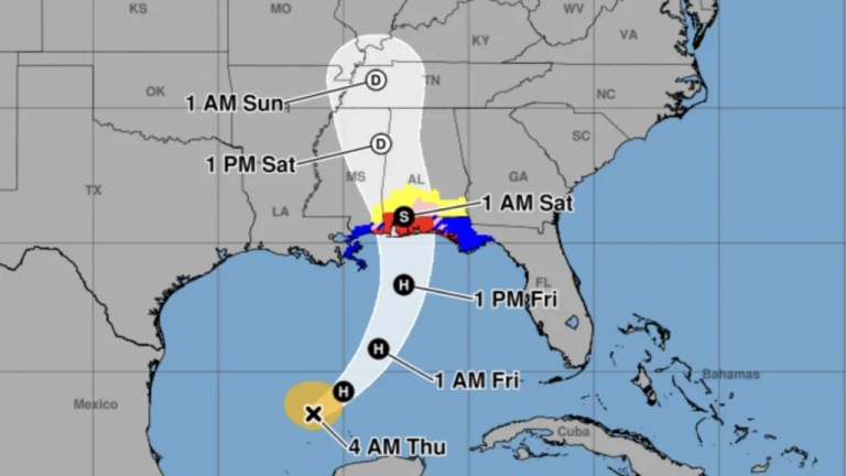
Hurricane Isaias is expected to make landfall sometime this evening, most likely between Mobile Bay and Choctawhatchee Bay, potentially near Pensacola.
The National Hurricane Center said the Category 3 storm’s winds had reached a maximum sustained speed of 120 miles per hour on Friday morning.
Obviously, the southernmost part of the state is in the most danger, but other regions of the state are also preparing for the effects of Isaias as it makes its way up Alabama this weekend.
“Damaging wind gusts from Isaias will extend well inland into Alabama, increasing the risk of downed trees and widespread power outages far from the coast. Two factors are increasing that threat: the storm’s rapid forward motion and its expanding wind field as it approaches the coast.
Isaias is hitting the Gulf Coast later in the hurricane season, when changing atmospheric conditions can make storms move faster and push damaging winds farther inland than during the summer months.”
Jonathan Porter, AccuWeather Chief Meteorologist
South Alabama

South Alabama has been preparing for this storm for a couple of days now, as the official hurricane watch went into effect Wednesday, October 8.
One of the biggest concerns with Hurricane Isaias is storm surge, a rush of water pushed onshore by a storm.
For Isaias, forecasters say the most significant surge threat is on the eastern side of the storm, near and east of where it comes ashore. Onshore winds there pile water into bays and estuaries. AccuWeather forecasts a surge of 6 to 10 feet over Alabama and the western Florida Panhandle Friday night into Saturday morning, Oct. 10.
Mobile and Baldwin counties both base their evacuation zones mainly on storm surge risk, not wind. So even if you plan to ride out the wind, it’s worth knowing your zone.
Officials with Alabama Power said more than 5,700 additional resources from 25 states are coming in to help, and crews, equipment and teams are being positioned where they’ll be ready to get to work quickly and safely if outages occur.
Central Alabama

The hurricane is expected to impact Central Alabama with potential for gusty winds, isolated tornadoes and localized flooding, according to the National Weather Service in Birmingham.
Alabama Power said their crews are being staged and will be ready to respond in affected areas after the storm passes.
“Preparation is one of the most important parts of storm response. Our teams train and plan for events like this throughout the year, and that preparation gives us the flexibility to make informed decisions and adapt as the forecast and potential impacts become clearer.”
Scott Moore, senior vice president of Power Delivery for Alabama Power
The Montgomery area can anticipate changing conditions as the outer bands of Hurricane Isaias move into the area. Significant weather impacts are expected to ramp up Friday evening heading into Saturday.
The City of Montgomery is working alongside key elected officials and public safety partners as the storm approaches.
North Alabama

According to the National Weather Service in Huntsville, the Huntsville area will see a medium to high chance of impactful gusty winds as Isaias moves rapidly northward after making landfall, and “a low-medium risk of flooding due to heavy rainfall.”
As far as tornadoes are concerned, the NWS reports a marginal risk of thunderstorms producing a tornado or two Saturday in north central and northeast Alabama.
North Alabama is expected to see up to half an inch of rainfall Saturday. While tornadoes are not likely, wind gusts as high as 35 mph are probable. This could cause power outages in the area.
“Huntsville Utilities is closely monitoring the weather situation and preparing for Hurricane Isaias’ impacts in our area and on our customers.
Obviously, there are some things we can’t do until the storm arrives, but crews are ready to respond when the time comes. This includes our electric line crews, tree clearing crews, etc. Our approach is always, ‘plan for the worst, hope for the best.’”
Todd Long, Huntsville Utilities
Safety measures
Because of the threat of high winds and flooding, the following precautions are suggested:
- Secure Outdoor Items: Bring inside or tightly secure anything that can be picked up by 40 to 60 mph wind gusts, such as patio furniture, garbage cans, potted plants and Halloween decorations.
- Park Vehicles Safely: If possible, park cars in garages or away from large trees. Saturated soil combined with high winds makes mature trees highly susceptible to falling.
- Clear Drainage Paths: Ensure your gutters, downspouts and nearby storm drains are clear of leaves and debris to prevent localized flash flooding around your home.
- Prepare for Outages: Widespread electrical outages are highly anticipated. Charge all cell phones, tablets, external battery packs and medical devices.
- Gather Emergency Lighting: Locate flashlights and fresh batteries. Avoid using candles due to the risk of accidental fires.
- Food and Water: Ensure you have enough non-perishable food and water for your family (and pets) to last at least 3 days in case utility restoration takes time.
- Keep Your Fridge Cold: Turn your refrigerator and freezer to their coldest settings today. If you lose power, keep the doors closed as much as possible to preserve food.
- Stay Off the Roads: Travel will become highly hazardous after midnight Friday and through Saturday morning. Do not drive through flooded roadways.