Tropical Storm Arthur could impact Alabama: What you need to know

Reading time: 2 minutes

The first named storm of the year has arrived as Tropical Storm Arthur is expected to make an impact on the Gulf Coast + in the southeast.
The National Weather Service has officially issued a public advisory, upgrading what was once a “potential tropical cyclone” to Tropical Storm Arthur.
Make sure to stay tuned to your local meteorologists + the National Weather Service for the latest forecasts.
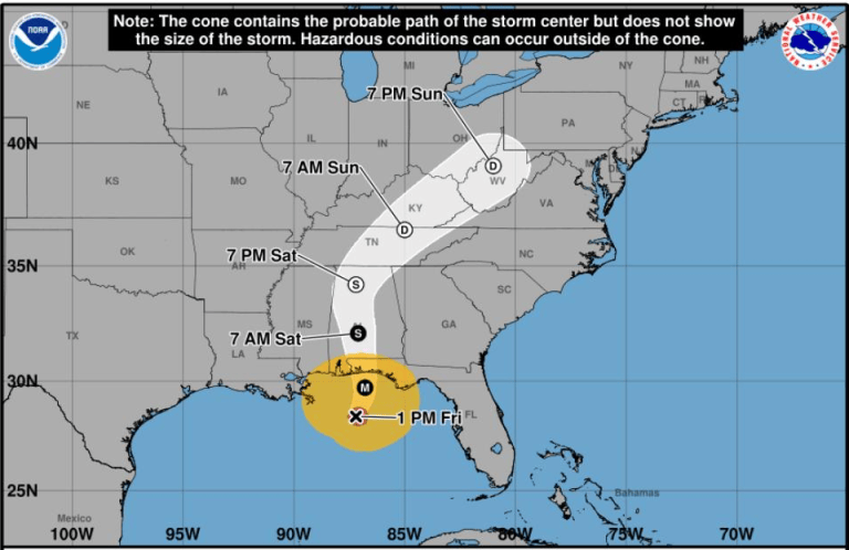
The storm is currently in the Gulf just off the Texas coast but it is expected to move across the coast line before moving inland, bringing large amounts of rain Thursday + Friday to Alabama.
Keep reading for everything you need to know to prepare for the storm in Alabama.
Storm expected to bring flash flood threat

The National Weather Service issued an alert for life-threatening flash floods expected for parts of the Southeast.
The southern half of our state has at least a 40% risk of flash floods between Thursday, June 18 and Saturday, June 20.
By the time the storm reaches Alabama, it is not expected to remain at Tropical Storm strength but it could still pack a punch with plenty of precipitation + high wind speeds.
Here are some of the rainfall projections from the National Weather Service:
- Fairhope, Foley, Mobile, Spanish Fort: 6-8 inches
- Dothan, Montgomery, Selma, Troy: 4-6 inches
- Birmingham, Anniston, Talladega, Tuscaloosa: 2-4 inches
- Cullman, Gadsden, Florence: 1-2 inches